


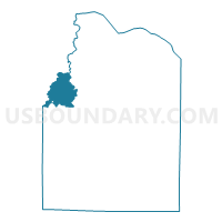
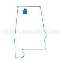
Wolf Springs Community Church, Lawrence County, Alabama
About
Outline

Summary
| Unique Area Identifier | 522247 |
| Name | Wolf Springs Community Church |
| County | Lawrence County |
| State | Alabama |
| Area (square miles) | 19.89 |
| Land Area (square miles) | 19.67 |
| Water Area (square miles) | 0.23 |
| % of Land Area | 98.87 |
| % of Water Area | 1.13 |
| Latitude of the Internal Point | 34.60586950 |
| Longtitude of the Internal Point | -87.46835230 |
Maps

Graphs
Select a template below for downloading or customizing gragh for Wolf Springs Community Church, Lawrence County, Alabama


Neighbors
Neighoring Voting District (by Name) Neighboring Voting District on the Map
- Donald Church (Town Creek), Lawrence County, AL
- Flat Rock Community Church, Lawrence County, AL
- Hattan Masonic Hall, Lawrence County, AL
- Lagrange Fire Dept., Colbert County, AL
- Leighton, Colbert County, AL
- St Cross Road, Franklin County, AL
Top 10 Neighboring County Subdivision (by Population) Neighboring County Subdivision on the Map
- Russellville CCD, Franklin County, AL (19,130)
- Leighton CCD, Colbert County, AL (8,253)
- Town Creek-Courtland CCD, Lawrence County, AL (4,655)
- Hatton CCD, Lawrence County, AL (4,615)
Top 10 Neighboring Unified School District (by Population) Neighboring Unified School District on the Map
- Lawrence County School District, AL (34,339)
- Colbert County School District, AL (23,875)
- Franklin County School District, AL (21,874)
Top 10 Neighboring State Legislative District Lower Chamber (by Population) Neighboring State Legislative District Lower Chamber on the Map
- State House District 18, AL (43,784)
- State House District 3, AL (42,348)
- State House District 7, AL (40,956)
Top 10 Neighboring State Legislative District Upper Chamber (by Population) Neighboring State Legislative District Upper Chamber on the Map
- State Senate District 1, AL (135,057)
- State Senate District 4, AL (123,291)
- State Senate District 6, AL (117,045)
Top 10 Neighboring 111th Congressional District (by Population) Neighboring 111th Congressional District on the Map
Top 10 Neighboring Census Tract (by Population) Neighboring Census Tract on the Map
- Census Tract 9792, Lawrence County, AL (4,655)
- Census Tract 9793, Lawrence County, AL (4,615)
- Census Tract 9729, Franklin County, AL (4,008)
- Census Tract 208.02, Colbert County, AL (3,766)